Spatial Data Infrastructures
Throughout this module, I gained a comprehensive overview over the following topics: Standards and Standardisation Organisations, Metadata, OGC Services (such as WMS, WFS, WCS, …), OGC APIs, Distributed Architectures, Geospatial Data Modelling (UML, GML, …), Relational Geodatabases and SQL, Ontologies, Semantic Web, Internet of Things (IoT), Initiatives (INSPIRE, GEOSS, Open Government Data, …), Cloud Computing, Open vs. Closed/Private/Proprietary, Working with and Publishing Geodata and Services. This post provides a selection of key concepts.
The module „Spatial Data Infrastructures“ covers three courses:
- Design of Geospatial Data Models (Lecture)
- OpenGIS: Standards, Architectures and Services (Lecture)
- SDI Services Implementation (Integrated Project)
Key Terminology

Spatial data infrastructure (= SDI)
= the technology, policies, standards, and human resources necessary to acquire, process, store, distribute, and improve utilization of geospatial data, services, and other digital resources.
Interoperability
= means the possibility for spatial data sets to be combined, and for services to interact, without repetitive manual intervention, in such a way that the result is coherent and the added value of the data sets and services is enhanced.


Data standard
= a commonly agreed specification on how data should be recorded and described.
Data model
= an abstract model that organises elements of data and standardises how they relate to each other and the real world, and it defines the structure and format (e.g. XML, JSON, …) of data.
[lecture notes]


Entity
= a thing that exists either physically or logically; an entity is a single instance of an entity type; a relationship describes, how entities are related to each other (e.g. via inheritance, association, aggregation, composition. Cardinalities include: one-to-one, one-to-many, many-to-many, with itself).
[lecture notes]
Database normalisation
= organising data by splitting and putting them in a separate table, and giving them relationships
to reduce redundance and minimize redesign efforts (leads to higher quality, interoperability, less complexitiy). The most common forms of normalisation are: 1NF, 2NF, 3NF.
[lecture notes]


Key
= is used to uniquely identify a record in a table. (Primary key, e.g. StudentID)
Other types of keys include: alternative key, composite key, candidate key, foreign key, natural key, surrogate key.
[lecture notes]
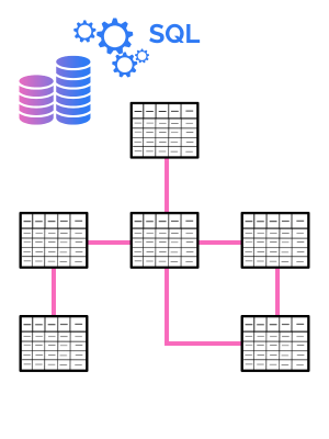
Relational database
= a database that organises the data into tables with rows and columns. Tables can have certain relationships. Keys are used to access the data/tables. Relational Database Management Systems (RDMS) allow manipulations of the contents using SQL. An example would be a student database where one table contains the students and another table contains the courses. The studentID can act as a primary key to access a table of the courses a specific student (= an entity of type student with attributes like: firstname, lastname, enrollmentdate, birthday, …) took.
Client-Server-Architecture
DATA TIER (DATABASES) – authoring
- responsible for storing, managing data
- e.g., Oracle Spatial, Esri Geodatabases, PostGIS, MSSQL, file-formats (Esri-shapefile, GeoJSON, …)
- usecase: provides data to logical tier
LOGICAL TIER (SERVER) – sharing
- responsible for data processing, analysis
- e.g., ArcGIS Server, Geoserver, RESTful APIs, spatial libraries, …
- usecase: processes user selection and requests data from data tier; forwards it to client
PRESENTATION TIER (CLIENT) – using
- responsible for the user interface and display of maps
- collects user input
- e.g., web clients (Leaflet, OpenLayers), ArcGIS Pro, QGIS, Google Maps, …
- usecase: user selects item on map; data is displayed
Finding Data
Geoportals
Geoportals are used to browse through spatial datasets. They can be of local or global dimension. Usually, data in a geoportal have metadata (data about the data, see below) attached. Geoportals and their data can be accessed via different requests and the data can be implemented in web maps or in GI software such as ArcGIS or QGIS. Geoportals play a key role in making data accessible openly and by the public. In this context, countries increasingly provide data publicly via open government data (=OGD) portals.
Examples of Geoportals:
Metadata
Metadata is information about data. This includes, e.g., the author(s), the creation date, the bounding box (= bbox), contact information, last updated, keywords on the content/theme of the dataset, title, coordinate reference system, licence, link to metadata XML file … Click here to see an example.
Make sure you include metadata! This serves you when you do not use the data for a longer time, or others, when you share it. It also helps to make the data transparent, to find it more easily, and with that it increases the quality of the data.
Watch the video on „Metadata in ArcGIS Pro“:
Catalogue Services
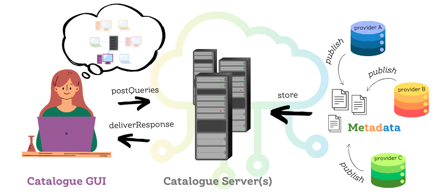
Catalogue services are similar to geoportals, but they focus on metadata search, specifically. They are rather targeted at professionals and researchers, compared to public portals that provide data for the general public. With them, users can find links to the documents they need, based on e.g. keywords in the metadata. This is one more reason to carefully fill in the metadata information! The OGC CSW provides a standard for publishing and searching metadata.
Click here to learn more about metadata and catalogue services.
Recap: Protocols
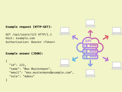
REST
– REpresentational State Transfer
new(er), uses HTTP, CSV, JSON
used with APIs, web apps
more lightweight and flexible
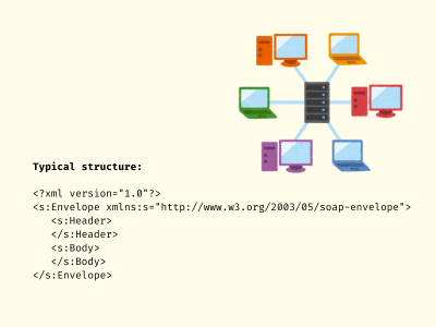
SOAP
– Simple Object Access Protocol
older, relies on XML
used in legacy services (WMS, WFS, …)
more robust and secure
Working with Map Data
WMS
OGC legacy standard for Web Map Services
- Returns map images
- Important operations:
- GetCapabilities
- GetMap
- Further optional operations
- Based on SOAP
WMTS
OGC legacy standard for Web Map Tile Services
- Returns a tile (image)
- Important operations:
- GetCapabilities
- GetTile
- Further operations possible
- Based on SOAP
OGC API – Maps
New RESTful OGC API for Maps
- Returns map images
- Part 1 is a standard (2025-03)
- Lightweight (RESTful)
Working with Feature Data
WFS
OGC legacy standard for Web Feature Services
- Returns features (point, line, polygone)
- Important operations:
- GetCapabilities
- GetFeature
- DescribeFeatureType
- Further operations possible
- Based on SOAP
OGC API -Features
New RESTful OGC API for Features
- Returns features (point, line, polygone)
- Parts 1 & 2 are standards (2025-03)
- Leightweight (RESTful)
Do we speak the same language…?
Communication is key. This is also true when we work in the field of SDI. In order that systems can communicate with each other or that we can communicate with them, we need to speak the same language. Here are some key schemas that a Geoinformatics professional should be familiar with:
UML
Unified Modelling Language
- ISO/IEC 19501:2004 standard
- visual expression of modelling structures or flows
- e.g., UML-activity diagram (dynamic behaviour of system) for the conceptual design of a simulation model
XML
eXtensible Markup Language
- W3C standard
- file-format standard to exchange information (store and transport data)
- human- and machine-readable format
KML
Keyhole Markup Language
- Google, later: OGC standard
- XML notation for geographic visualisation
- what to show and how to show information in an earth browser (end-user focus)
- e.g., routing, travel paths
GML
Geography Markup Language
- OCG & ISO 19136:2007 standard (ISO 19136:2020-1)
- XML notation for geographic data exchange (transport/storage)
- interoperability, data modelling (professional focus)
- e.g., WFS uses GML
GeoJSON
Geo JavaScript Object Notation
- open standard
- uses JSON (JavaScript Object Notation) for geographic data encoding (simple feature)
- used in mapping and visualisation
- simpler, and more lightweight than GML
- used for APIs and web mapping, e.g., Leaflet
SQL
Structured Query Language
- ISO/IEC 9075 (ISO/IEC 9075-1:2023)
- standard programming language used to manage and manipulate relational databases
- operations: SELECT, INSERT, UPDATE, DELETE (and others)
- used in spatial databases, like PostGIS, to store and query spatial data
WKT
Well-known text
- ISO/IEC 13249-3:2016
- used to represent vector geometries (point, linestring, polygone, TIN, …)
- simple, human-readable text-format, e.g., point (10 20)
- used in database storage or with APIs
WKB
Well-known binary
- standard to represent geometries in binary format
- not human-readable
- geometry types ‚are‘ integer codes
- easier format for processing
WKT-CRS
Well-known text representation for coordinate reference systems
- OGC/ISO 19162:2019
- used for the description of CRS as text, and operations between CRS
Hands-on…
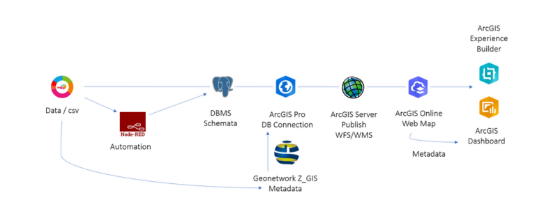
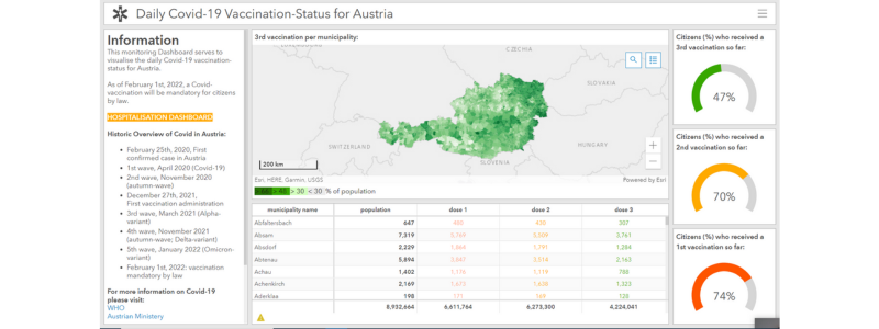
During the SDI Service Implementation course, my colleague Vanessa and I created a Covid-19-dashboard where we accessed latest case and vaccination data. The goal of the project was to create a mini covid-dashboard for Austria, that updates itself daily. The workflow and a screenshot of the dashboard are presented below.
Note: All images are from Pexels, made with Canva, or screenshots of project work.