Geo Application Development
In the Geoapplication Development course, I gained a theoretical overview on software development, and I learned how to design and implement interactive web-based mapping applications. I gained practical experience working with Java, JavaScript, HTML5, and CSS to create responsive and user-friendly interfaces. During this process, I developed a strong foundation in front-end development and learned how to integrate spatial data effectively into modern web applications. I had the pleasure to work together with my colleages Christina, Nik and Edah, in this module. The module „Geo-Application Development“ covers three courses:
- Software Development (Lecture)
- Software Development (Lab)
- Geo-Application Development (Lab)
Software Development
Software Engineering is a „systematic approach to the analysis, design, assessment, implementation, test, maintenance and reengineering of software, that is, the application of engineering to software“.
[lecture notes & Laplante, P.A. (2007)]

Software application areas in Geoinformatics…
- transportation
- naviagtion
- sports apps
- location-based services (restaurants, weather, …)
- process automation
- visualisation
- pre-processing
- disaster management
- many more…
Software quality requires…
- functionality
- usability
- performance
- reliability
- efficiency
- scalability
- extensibility
- security
- maintainability

Get started with…
Java
Java is a widely-used, object-oriented programming language known for its platform independence, thanks to the Java Virtual Machine (JVM). It’s commonly used for building enterprise-level applications, Android apps, and large-scale systems.
JavaScript/HTML5/CSS
JavaScript works alongside HTML5 and CSS to make websites dynamic and interactive. HTML5 structures the content, CSS styles it, and JavaScript adds behaviors like animations, form validation, or interactive buttons.
Python
Python is a beginner-friendly programming language celebrated for its simplicity and readability. It is used in diverse fields, such as web development, data analysis, artificial intelligence, and scientific computing.
Jupyter Notebooks
Jupyter Notebooks is a free and open-source online tool with which one can combine code sequences with text. This is especially useful for documenting assignments or research projects, and a go-to in data science communities.


Scripting in ArcGIS
ArcGIS Pro allows writing scripts and tools in Python, R, and you can build a Jupyter Notebook in your project.
Software Development (Lab)
In the Software Development lab, I worked on a project together with my colleagues Christina and Edah. We built a Java Dynamic Google Earth Tweet and WMS Mapper.

Documentation & Video Demos
Take a look at our project.
Geo-Application Development (Lab)
In the MINKT project during my Geo-Application Development class, I worked together with Christina and Niklas. We worked in an JS/HTML5/CSS environment to implement Survey123 results into this web application that we built from scratch.
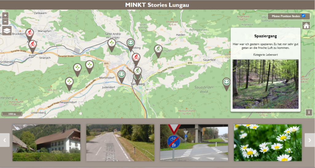
Documentation
Take a look at our project.
Note: The images are from Canva, or the project repositories.